![](/images/other/stat-length.png)
![Randonnée Marche Brusino Arsizio - M. S, Giorgio - Photo](https://media.geolcdn.com/t/1900/400/ext.pjpeg?maxdim=2&url=https%3A%2F%2Fstatic1.geolcdn.com%2Fsiteimages%2Fupload%2Ffiles%2F1553511878bg_sport_marche.png)
M. S, Giorgio
duamerg
Utilisateur
![Longueur](/images/other/stat-length.png)
![Altitude max](https://static1.geolcdn.com/siteimages/upload/files/1508320355ic_sort_altitude_max_24dp.png)
![Dénivelé positif](https://static1.geolcdn.com/siteimages/upload/files/1508320355ic_sort_den_pos_24dp.png)
![Km-Effort](/images/other/stat-length.png)
![Altitude min](https://static1.geolcdn.com/siteimages/upload/files/1508320355ic_sort_altitude_min_24dp.png)
![Dénivelé négatif](https://static1.geolcdn.com/siteimages/upload/files/1508320355ic_sort_den_neg_24dp.png)
![Boucle](https://static1.geolcdn.com/siteimages/upload/files/16400158638029165_repeat_loop_refresh_sync_direction_icon.png)
![Marche](https://static1.geolcdn.com/sitytour/trail-icons/101.png)
3h30
Difficulté : Moyen
![Scannez ce code QR pour ouvrir la randonnée dans l'application SityTrail](https://capi.geolives.com/qq0zvz2zws4bq2lad0pu/sitytour/trails/22031/qr.png?size=200)
Application GPS de randonnée GRATUITE
À propos
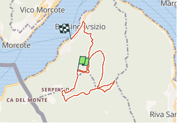
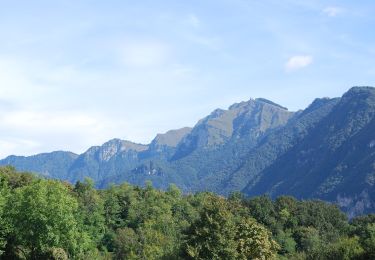
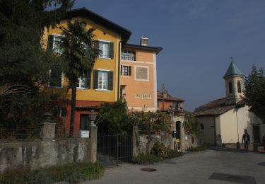
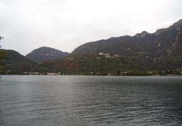
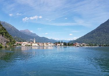
Randonnée Marche de 8,2 km à découvrir à Tessin, District de Lugano, Brusino Arsizio. Cette randonnée est proposée par duamerg.
Description
Prendre le téléphérique à Brusino, départ toutes les demi-heures.Suivre le sentier pour le Grotto de l'Alpe de Brusino. Depuis là, forte montée jusqu'au Mont S. Giorgio. Revenir sur ses pas et suivre les panneaux Serpiano. Forte descente avec belle vue sur Morcotte. De Serpiano rejoindre le téléphérique (restaurant avec vue). Descendre au village. Chemins en général glissants sur les cailloux ou la terre sabloneuse. Bonnes chaussures.
Localisation
Commentaires
Randonnées à proximité
![Randonnée A pied Porto Ceresio - Via Verde Varesina tappa 1 - Photo](https://media.geolcdn.com/t/375/260/e9575b87-6844-4d44-b855-68e97d696f12.jpeg&format=jpg&maxdim=2)
![A pied A pied](https://static1.geolcdn.com/sitytour/trail-icons/100.png)
A pied
![](/images/other/stat-length.png)
![](https://static1.geolcdn.com/siteimages/upload/files/16400158638029165_repeat_loop_refresh_sync_direction_icon.png)
![Randonnée A pied Porto Ceresio - (SI D07) Porto Ceresio - Viggiù - Photo](https://media.geolcdn.com/t/375/260/ec40e8c4-aaa2-4dd6-b1eb-f245da5a46e5.jpeg&format=jpg&maxdim=2)
![A pied A pied](https://static1.geolcdn.com/sitytour/trail-icons/100.png)
A pied
![](/images/other/stat-length.png)
![](https://static1.geolcdn.com/siteimages/upload/files/16400158638029165_repeat_loop_refresh_sync_direction_icon.png)
![Randonnée A pied Mendrisio - Itinerario](https://media.geolcdn.com/t/375/260/4a141307-4c40-4996-9897-8c55b55a38a6.jpeg&format=jpg&maxdim=2)
![A pied A pied](https://static1.geolcdn.com/sitytour/trail-icons/100.png)
A pied
![](/images/other/stat-length.png)
![](https://static1.geolcdn.com/siteimages/upload/files/16400158638029165_repeat_loop_refresh_sync_direction_icon.png)
![Randonnée A pied Melide - Melide-Vico Morcote - Photo](https://media.geolcdn.com/t/375/260/aa751a24-7b34-4794-903f-71b2aa17915a.jpeg&format=jpg&maxdim=2)
![A pied A pied](https://static1.geolcdn.com/sitytour/trail-icons/100.png)
A pied
![](/images/other/stat-length.png)
![](https://static1.geolcdn.com/siteimages/upload/files/16400158638029165_repeat_loop_refresh_sync_direction_icon.png)
![Randonnée A pied Mendrisio - Meride-Mendrisio Stazione - Photo](https://media.geolcdn.com/t/375/260/dbfb3492-361f-49ef-912a-3dc2d1cf9cda.jpeg&format=jpg&maxdim=2)
![A pied A pied](https://static1.geolcdn.com/sitytour/trail-icons/100.png)
A pied
![](/images/other/stat-length.png)
![](https://static1.geolcdn.com/siteimages/upload/files/16400158638029165_repeat_loop_refresh_sync_direction_icon.png)
![Randonnée A pied Lugano - Carona-Alpe Vicania - Photo](https://media.geolcdn.com/t/375/260/80e04e5d-c3ad-4349-81fa-18933541e228.jpeg&format=jpg&maxdim=2)
![A pied A pied](https://static1.geolcdn.com/sitytour/trail-icons/100.png)
A pied
![](/images/other/stat-length.png)
![](https://static1.geolcdn.com/siteimages/upload/files/16400158638029165_repeat_loop_refresh_sync_direction_icon.png)
![Randonnée A pied Melano - Maroggia - Bissone - Photo](https://media.geolcdn.com/t/375/260/6ea1aab7-8066-4101-bf93-9bc5e27b1b49.jpeg&format=jpg&maxdim=2)
![A pied A pied](https://static1.geolcdn.com/sitytour/trail-icons/100.png)
A pied
![](/images/other/stat-length.png)
![](https://static1.geolcdn.com/siteimages/upload/files/16400158638029165_repeat_loop_refresh_sync_direction_icon.png)
![Randonnée Vélo Brusimpiano - venetië dag 19 - Photo](https://media.geolcdn.com/t/375/260/ext.jpg?maxdim=2&url=https%3A%2F%2Fservices.sitytrail.com%2FGeolivesWS%2FDownloadMedia.ashx%3FTrailID%3D774049%26Media%3Dfix__20170616144708.jpg)
![Vélo Vélo](https://static1.geolcdn.com/sitytour/trail-icons/200.png)
![Randonnée Marche Mendrisio - hike31 - Photo](https://media.geolcdn.com/t/375/260/ext.jpg?maxdim=2&url=https%3A%2F%2Fstatic1.geolcdn.com%2Fsiteimages%2Fupload%2Ffiles%2F1553511878bg_sport_marche.png)
![Marche Marche](https://static1.geolcdn.com/sitytour/trail-icons/101.png)
Marche
![](/images/other/stat-length.png)
![](https://static1.geolcdn.com/siteimages/upload/files/16400158638029165_repeat_loop_refresh_sync_direction_icon.png)